Quiet Atlantic Could Stir Soon, What It Means for North Carolina
Understanding the Current Lull in Tropical Activity
Since late August, tropical activity in the Atlantic Basin has been unusually quiet. Typically, this time of year marks the peak of hurricane season, with the most active period running from late August through mid-October. However, this year, the tropics have remained calm, with no named storms forming since August 28 and no hurricanes since August 22. While such lulls are not unheard of, they can be misleading, as tropical systems can develop rapidly, especially in September.
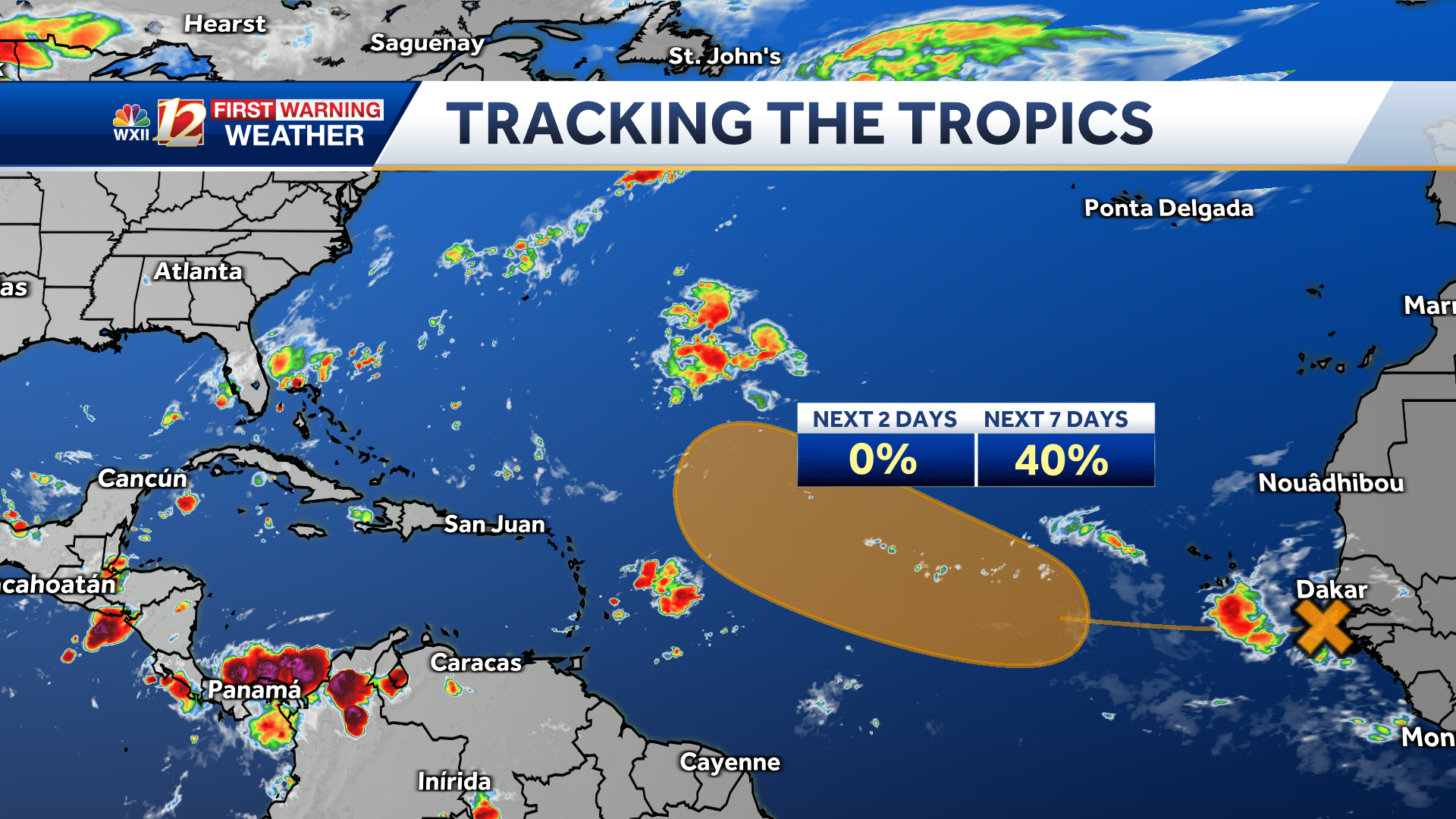
The National Hurricane Center has noted that a tropical wave is currently emerging off the coast of Africa and moving into the eastern Atlantic. This disturbance could potentially develop into a tropical depression or storm over the central Atlantic in the coming days. Although the chances are moderate, it’s important to stay informed and watch for updates.
Climatological Peak and Environmental Factors
The climatological peak of the Atlantic hurricane season occurs on September 10, but this year, the basin has seen little activity. One possible reason for the slowdown is the presence of dry air over the U.S. East Coast, which has been persistent due to troughing. This dry air can inhibit the formation of tropical systems. However, meteorologists believe that this lull may be temporary, as some models suggest that additional tropical waves could develop in the eastern tropical Atlantic over the next week.
Despite the current calm, the season is far from over. The National Oceanic and Atmospheric Administration (NOAA) continues to project a near or above-average season, with 13 to 18 named storms expected, including five to nine hurricanes and up to five major hurricanes. Colorado State University also forecasts 16 named storms, eight of which could become hurricanes, with three reaching major status.
Mid-Season Review: What Has Happened So Far
This season started with a brief surge in activity in mid-August. Hurricane Erin briefly reached Category 5 strength in the Southwest Atlantic before turning north, bringing large swells and rough surf to the U.S. East Coast. It was followed by Tropical Storm Fernand, which did not make landfall. Since then, the Atlantic has remained quiet.
So far, six named storms have formed in the basin, but only one has reached hurricane status—Erin. Erin was the third storm to impact North Carolina this season. Earlier in July, Tropical Storm Chantal caused severe flooding and claimed at least six lives in central North Carolina. In August, Tropical Storm Dexter brought heavy rain and gusty winds to parts of eastern North Carolina before dissipating.
North Carolina has already experienced three tropical systems this year, either directly or indirectly, which is half of the total number of named storms. While the region is currently quiet, the season is only halfway through, and more activity is expected.
Historical Patterns and Future Outlook
Historically, periods of quiet tropical activity have often been followed by surges in development. For example, in 2024, there was a nearly three-week lull in late August and early September, after which the Atlantic saw 13 named storms in just ten weeks, including major hurricanes like Helene, Kirk, Milton, and Rafael. A similar pattern occurred in 2022.
These historical trends suggest that the current calm is likely temporary. Meteorologists expect the most volatile part of the season to come in the next few weeks, particularly in September and October.
Key Areas to Monitor
Over the next few weeks, the WXII 12 First Warning Weather Team will be closely monitoring three key areas for potential tropical development:
- The Gulf: Warm sea surface temperatures can allow storms to intensify quickly under favorable atmospheric conditions.
- Africa: Low-pressure waves often move from the Sahara Desert into the eastern Atlantic, where they can develop into tropical systems.
- Southeast U.S. Coast: Weaker, short-lived storms can form along old frontal boundaries, and these systems can become dangerous quickly if they approach the coast.
Staying Prepared for the Upcoming Season
While the tropics are quiet now, the historically busiest months of the hurricane season still lie ahead. Residents of the Piedmont Triad should remain alert, informed, and prepared. Here are some essential steps to take:
- Know your evacuation routes and have an emergency plan in place.
- Monitor forecasts through WXII 12 News or WXII12.com.
- Review insurance coverage and protect important documents, especially in light of past events like Helene (2024) and Chantal (2025).
- Build an emergency preparedness kit with essentials like water, batteries, flashlights, and medications.
Interactive Resources and Additional Coverage
For more information and interactive content, viewers can explore the WXII Interactive Studio. There, they can watch videos explaining the impacts of past storms, how to prepare for future ones, and the long-term effects of major hurricanes.
Additional weather coverage includes alerts, traffic updates, and the latest forecasts. Residents can also share photos in the local North Carolina Facebook Group or download the WXII12 News mobile app for real-time updates.
As the season progresses, staying informed and prepared is crucial. Even though the tropics are quiet now, the potential for increased activity remains high, and vigilance is necessary throughout the remainder of the hurricane season.
Post a Comment